
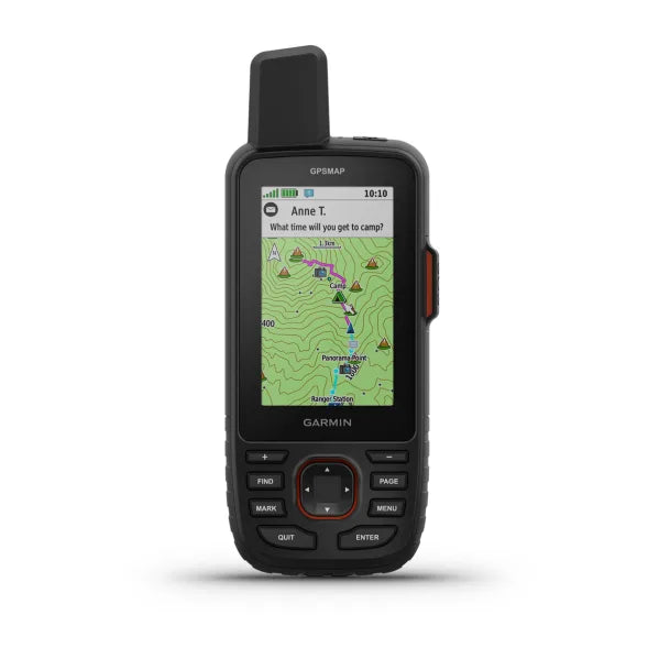
Garmin GPSmap 67i
GPS Handheld and Satellite Communicator
P/N 010-02812-02
Make more time for adventure with this premium, rugged GPS handheld and satellite communicator. Get inReach® technology that enables two-way messaging, interactive SOS alerts and location sharing plus mapping to keep you on course.
- Large, 3” sunlight-readable color display for easy viewing
- Multiple Global Navigation Satellite Systems (GNSS) support to track your travels in more challenging environments than GPS alone plus three-axis compass and barometric altimeter
- Expanded wireless connectivity supports Active Weather for up-to-date forecasts and animated weather radar and Geocaching Live for mobile syncing and updates
- Compatible with Garmin Explore™ website and app to help you manage tracks, routes and waypoints and review statistics from the field
- Up to 180 hours of battery life in GPS mode; 425 hours in expedition mode lets you explore longer than ever before on internal lithium battery
TWO-WAY MESSAGING
Exchange text messages with loved ones or friends, post to social media, or communicate from inReach to inReach in the field. Satellite subscription required.
In case of emergency, trigger an interactive SOS message to GEOS, a professional 24/7 global monitoring and response centre. Satellite subscription required.
Track your location, and share it with those at home or out in the field. They’ll be able to see your progress or ping your device for your GPS location and more. Satellite subscription required.
LOCATION SHARING100% GLOBAL IRIDIUM® SATELLITE NETWORK
Instead of relying on mobile coverage, now your messages, SOS alerts and tracking are transferred via the global Iridium satellite network. Satellite subscription required.
Use inReach connectivity to get detailed weather updates on GPSMAP 66i or a compatible device paired with the Garmin Explore™ app. Request weather forecasts for your current location, waypoints or destinations on your route.
OPTIONAL INREACH WEATHERWhen paired with your compatible smartphone you can get real-time forecast information and live weather radar, so you’re always aware of the surrounding conditions.
ACTIVE WEATHERIn the Box:
- GPSMAP 67i
- Type A to Type C USB cable
- Carabiner clip
- Documentation
General |
|
| DIMENSION | 6.2 x 16.3 x 3.5 cm (2.5″ x 6.4″ x 1.4″) |
|---|---|
| DISPLAY SIZE | 3.8 x 6.3 cm (1.5″W x 2.5″H ); 7.6 cm diag (3″) |
| DISPLAY RESOLUTION | 240 x 400 pixels |
| DISPLAY TYPE | Transflective colour TFT |
| WEIGHT | 230 g with batteries |
| WATERPROOF | IPX7 |
| BATTERY TYPE | Rechargeable, internal lithium-ion |
| BATTERY LIFE | Up to 165 hours with inReach® enabled with 10 minute tracking Up to 180 hours in GPS Mode Up to 425 hours in Expedition mode with inReach enabled Up to 425 hours in expedition mode |
| MIL-STD-810 | Yes (thermal, shock, water); bare unit only |
| INTERFACE | USB-C |
| MEMORY/HISTORY | 16 GB (user space varies based on included mapping) |
Maps & Memory |
|
| PRELOADED MAPS | Yes (TopoActive Australia & New Zealand, routable) |
|---|---|
| ABILITY TO ADD MAPS | Yes |
| BASEMAP | Yes |
| AUTOMATIC ROUTING (TURN BY TURN ROUTING ON ROADS) FOR OUTDOOR ACTIVITIES | Yes |
| MAP SEGMENTS | 15,000 |
| SATELLITE IMAGERY | Yes (direct to device) |
| INCLUDES DETAILED HYDROGRAPHIC FEATURES (COASTLINES, LAKE/RIVER SHORELINES, WETLANDS AND PERENNIAL AND SEASONAL STREAMS) | Yes |
| INCLUDES SEARCHABLE POINTS OF INTERESTS (PARKS, CAMPGROUNDS, SCENIC LOOKOUTS AND PICNIC SITES) | Yes |
| DISPLAYS NATIONAL, STATE AND LOCAL PARKS, FORESTS, AND WILDERNESS AREAS | Yes |
| EXTERNAL MEMORY STORAGE | Yes (32 GB max microSD™ card) |
| WAYPOINTS/FAVORITES/LOCATIONS | 10,000 |
| COURSES | 250, 200 course points per course |
| TRACKS | 250 |
| NAVIGATION TRACK LOG | 20,000 points, 250 saved gpx tracks, 300 saved fit activities |
| ACTIVITIES | Yes |
| NAVIGATION ROUTES | 250, 250 points per route; 50 points auto routing |
| RINEX LOGGING | Yes |
Sensors |
|
| HIGH-SENSITIVITY RECEIVER | Yes |
|---|---|
| GPS | Yes |
| GALILEO | Yes |
| QZSS | Yes |
| BEIDOU | Yes |
| IRNSS | Yes |
| BAROMETRIC ALTIMETER | Yes |
| COMPASS | Yes (tilt-compensated 3-axis) |
| GPS COMPASS (WHILE MOVING) | Yes |
| MULTI-BAND FREQUENCY | Yes |
Yes
Daily Smart Features |
|
| CONNECT IQ™ (DOWNLOADABLE WATCH FACES, DATA FIELDS, WIDGETS AND APPS) | Yes |
|---|---|
| SMART NOTIFICATIONS ON HANDHELD | Yes |
| VIRB® REMOTE | Yes |
| PAIRS WITH GARMIN CONNECT™ MOBILE | Yes |
| ACTIVE WEATHER | Yes |
Safety and Tracking Features |
|
| LIVETRACK | Yes |
|---|---|
Outdoor Recreation |
|
| POINT-TO-POINT NAVIGATION | Yes |
|---|---|
| TRACBACK® | Yes |
| AREA CALCULATION | Yes |
| HUNT/FISH CALENDAR | Yes |
| SUN AND MOON INFORMATION | Yes |
| XERO™ LOCATIONS | Yes |
| GEOCACHING-FRIENDLY | Yes (Geocache Live) |
| CUSTOM MAPS COMPATIBLE | Yes (500 custom map tiles) |
| PICTURE VIEWER | Yes |
| LED BEACON FLASHLIGHT | Yes |
inReach® Features |
|
| INTERACTIVE SOS | Yes |
|---|---|
| INREACH WEATHER | Yes |
| SEND AND RECEIVE TEXT MESSAGES TO SMS AND EMAIL | Yes |
| SEND AND RECEIVE TEXT MESSAGES TO OTHER INREACH DEVICE | Yes |
| SEND AND RECEIVE GROUP MESSAGES | Yes |
| EXCHANGE LOCATIONS WITH OTHER INREACH DEVICE | Yes |
| MAPSHARE COMPATIBLE WITH TRACKING | Yes |
| VIRTUAL KEYBOARD FOR CUSTOM MESSAGING | Yes |
| SEND WAYPOINTS TO MAPSHARE DURING TRIP | Yes |
| SEND ROUTE SELECTION TO MAPSHARE DURING TRIP | Yes |
Outdoor Applications |
|
| COMPATIBLE WITH GARMIN EXPLORE™ APP | Yes |
|---|---|
| GARMIN EXPLORE WEBSITE COMPATIBLE | Yes |
| COMPATIBLE WITH GARMIN MESSENGER APP | Yes |
| SMART SWITCHING BETWEEN WI-FI, MOBILE AND SATELLITE WITH GARMIN MESSENGER APP | Yes |
Connections |
|
| CONNECTIONS WIRELESS CONNECTIVITY | Yes (Wi-Fi®, Bluetooth®, ANT+®) |
|---|---|